

Mount Hood Hikes
From Oregon Hikers Field Guide
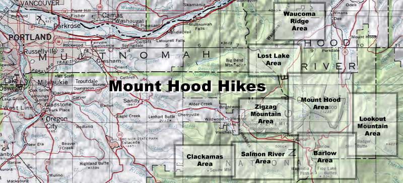

Contents |
Waucoma Ridge Area
| Hike | Difficulty | Distance | Elevation Change | Notes | |
| Waucoma Ridge Area | |||||
| Mount Defiance from Wahtum Lake Road Hike | Easy | 3.2 | 1145 | The short route to the Mt. Defiance summit | |
| Bear Lake Hike | Easy | 2.6 | 480 | Up and down walk to a secluded lake | |
| Waucoma Lakes Loop Hike | Difficult | 16.5 | 3170 | Visit four lakes on the north side of Waucoma Ridge and get some views, too! | |
| Green Point Mountain Loop Hike | Moderate | 8.0 | 1275 | Easily graded hike to a ridge high point and two lakes | |
| Mud Lake Hike | Moderate | 7.4 | 1400 | Moderate hike to a secluded lake below Waucoma Ridge | |
| Tomlike Mountain Hike | Moderate | 6.8 | 1565 | Take a user trail along the wide open Woolly Horn Ridge | |
| Chinidere Mountain Hike | Moderate | 5.6 | 1140 | Wahtum Lake and views from Chinidere summit | |
Lost Lake Area
| Hike | Difficulty | Distance | Elevation Change | Notes | |
| Lost Lake Area | |||||
| Lost Lake Butte Hike | Moderate | 4.6 | 1270 | Climb to peak with Mt Hood Views | |
| Lost Lake Loop Hike | Easy | 3.2 | 100 | Easy hike around lake | |
| Buck Peak Hike | Difficult | 15.8 | 2500 | Difficult hike to rocky viewpoint | |
Zigzag Mountain Area
| Hike | Difficulty | Distance | Elevation Change | Notes | |
| From Old Maid Flat | |||||
| Cast Creek Hike | Moderate | 12.4 | 2970 | Ridge climb to beargrass meadows | |
| Horseshoe Ridge Hike | Moderate | 10.8 | 2700 | Ridge climb to views of Mount Hood | |
| East Zigzag from Lost Creek Hike | Difficult | 9.4 | 2300 | Burnt Lake and mountain views | |
| Paradise Park via Burnt Lake Hike | Difficult | 15.6 | 3400 | The "long" way to Paradise Park | |
| From Highway 26 | |||||
| West Zigzag Hike | Difficult | 11.2 | 2900 | Forest climb to rocky lookout site | |
| Castle Canyon Hike | Easy | 2.2 | 840 | Leafy hike to pinnacles composed of volcanic breccia | |
| East Zigzag from Devil Canyon Hike | Difficult | 8.0 | 1670 | Forest hike to mountain views | |
| Paradise Park Hike | Difficult | 11.4 | 3000 | Summer wildflower hike | |
| Zigzag Overlook from Hidden Lake Hike | Difficult | 12.0 | 2800 | Forest hike to a mountain viewpoint | |
| Little Zigzag Falls Hike | Easy | 0.6 | 50 | Short hike to nice waterfall | |
| Enid Lake via Pioneer Bridle Trail Hike | Moderate | 9.5 | 1570 | Ascend Laurel Hill on historic travel routes | |
| Laurel Hill Chute Loop Hike | Easy | 0.6 | 230 | View one of the difficult descent routes on the Oregon Trail | |
Salmon River Area
| Hike | Difficulty | Distance | Elevation Change | Notes | |
| From Salmon River Road | |||||
| Old Salmon River Hike | Easy | 5.0 | 200 | Family trail through ancient forest along ode the pristine Salmon River | |
| Salmon River Hike | Moderate | 7.8 | 950 | Popular hike through a rugged, forested canyon | |
| Kinzel Lake Hike | Difficult | 17.2 | 3455 | Hike up the Salmon River Canyon and then take a dry slope to a secluded lake | |
| Green Canyon-Salmon River Loop Hike | Difficult | 15.6 | 4355 | Loop visiting various highlights of the Salmon-Huckleberry Wilderness | |
| Still Creek Area | |||||
| Devil's Peak from Cool Creek Hike | Difficult | 7.6 | 3200 | Challenging climb from valley floor to summit | |
| South of Highway 26 | |||||
| Cascade Streamwatch Loop Hike | Easy | 4.4 | 40 | Interpretive trails through shady forest on the Salmon River | |
| Boulder Ridge to Huckleberry Mountain Hike | Difficult | 10.6 | 3450 | Steep climb to a ridge top viewpoint with easy trailhead access | |
| Huckleberry Mountain via Bonanza Trail Hike | Difficult | 11.8 | 3485 | Little-used trail up a pristine creek and then to a ridgetop viewpoint | |
| Hunchback Mountain Hike | Moderate | 9.0 | 3270 | Steep trail along a forested ridge to a viewpoint | |
| Devil's Peak from Hunchback Mountain Hike | Difficult | 15.4 | 5940 | Rugged wilderness ridge hike to a lookout and viewpoint | |
| Government Camp Area | |||||
| Mirror Lake Hike | Easy | 2.9 | 780 | Popular family hike with famous views | |
| Tom Dick and Harry Mountain Hike | Moderate | 6.6 | 1520 | Spectacular views from a rocky crest | |
| Multorpor Mountain Loop Hike | Moderate | 5.1 | 1100 | Hike to a summit with views and then loop back through Skibowl | |
| West Fork Falls Hike | Easy | 2.6 | 405 | Unofficial trail to a hidden waterfall; loop option also described | |
| Near Sherar Burn Road | |||||
| Trillium Lake Loop Hike | Easy | 1.9 | 10 | Loop through bog and forest with views and wildflowers | |
| Veda Lake Hike | Easy | 2.8 | 660 | Easy family hike to secluded lake | |
| Devil's Peak Hike | Easy | 3.0 | 660 | Forest trail with mountain views | |
Mount Hood Area
| Hike | Difficulty | Distance | Elevation Change | Notes | |
| Timberline Lodge Area | |||||
| Paradise Park from Timberline Lodge Hike | Difficult | 12.1 | 2300 | Most popular segment of the Timberline Trail | |
| Mountaineer Trail Loop Hike | Easy | 2.7 | 1065 | Family-friendly alpine hike to 7,000 feet | |
| Timberline Trail around Mount Hood Hike | Difficult | 38.9 | 8000 | A Pacific Northwest classic | |
| Mount Hood Meadows via White River Canyon Hike | Moderate | 9.0 | 2320 | Rugged White River Canyon traverse, buried forest, and high meadows | |
| Zigzag Overlook from Timberline Lodge Hike | Easy | 4.4 | 400 | Alpine trek to the canyon rim | |
| Ramona Falls Area | |||||
| Paradise Park from Ramona Falls Hike | Difficult | 13.8 | 3400 | Challenging hike to alpine meadows | |
| Ramona Falls Hike | Moderate | 7.0 | 1100 | Pretty loop passes a lacy waterfall | |
| Yocum Ridge Hike | Difficult | 16.0 | 3600 | Challenging hike to amazing alpine viewpoints | |
| From Lolo Pass Road | |||||
| Bald Mountain from Top Spur Hike | Easy | 2.0 | 550 | Short hike to an old lookout site with a spectacular mountain view | |
| Bald Mountain from Lolo Pass Hike | Moderate | 6.6 | 1400 | Hike through quiet forests to a spectacular viewpoint | |
| Muddy Fork Hike | Moderate | 6.2 | 800 | Hike to site of recent mudflows with beautiful mountain views | |
| Cairn Basin via Mazama Trail Hike | Moderate | 8.8 | 2465 | Popular summer access to wildflower meadows | |
| Cairn Basin from Top Spur Hike | Moderate | 8.7 | 2200 | Spectacular alpine traverse | |
| Cairn Basin from Vista Ridge Hike | Difficult | 7.6 | 1560 | Loop through beautiful mountain meadows | |
| Elk Cove from Vista Ridge Hike | Moderate | 8.8 | 1790 | Towering mountain views and wildflowers | |
| McNeil Point Hike | Difficult | 10.4 | 2200 | Close-up view of Mount Hood's sheer west face | |
| Owl Point from Vista Ridge Hike | Easy | 4.0 | 500 | Newly restored trail with spectacular views | |
| Perry Lake from Vista Ridge Hike | Moderate | 5.7 | 1000 | Newly restored trail and spectacular views | |
| Laurance Lake Area | |||||
| Elk Cove from Pinnacle Ridge Hike | Moderate | 8.4 | 2490 | Steep trail to avalanche lilies and Mount Hood's north face | |
| Elk Cove Hike | Moderate | 10.2 | 2200 | Mount Hood's most beautiful alpine basin | |
| Cloud Cap Area | |||||
| Cooper Spur Hike | Difficult | 6.4 | 2800 | Mount Hood's highest trail hike | |
| Eliot Moraine Hike | Moderate | 2.1 | 870 | Spectacular glacier views | |
| Elk Cove from Cloud Cap Hike | Difficult | 9.6 | 1600 | A classic hike for more than a century | |
| Gnarl Ridge from Cloud Cap Hike | Difficult | 8.4 | 2420 | High alpine traverse and ancient krummholz | |
| Tilly Jane Hike | Difficult | 3.6 | 1100 | Alpine hike with north face views | |
| From Highway 35 | |||||
| Tamanawas Falls Hike | Easy | 3.6 | 590 | Streamside hike to thundering falls | |
| Lamberson Spur Loop Hike | Difficult | 18.3 | 5035 | Take an unmaintained trail and then go cross-country above the timberline for a high, wild loop | |
| Bluegrass Ridge-Cold Spring Creek Loop Hike | Difficult | 15.5 | 3580 | Long remote loop using an abandoned trail, mostly through a burn | |
| Dog River Trail Hike | Moderate | 7.1 | 1600 | Shuttle hike above Hood River | |
| Bald Butte Hike | Moderate | 8.2 | 2100 | Climb through open meadows to a former lookout site | |
| Hood River Meadows Area | |||||
| Elk Meadows Hike | Moderate | 5.3 | 1200 | Mount Hood's largest meadows | |
| Elk Mountain-Elk Meadows Loop Hike | Moderate | 8.2 | 1445 | Reach Elk Meadows by detouring to a lookout site | |
| Gnarl Ridge from Hood River Meadows Hike | Difficult | 8.9 | 2460 | Canyon viewpoint and mountain meadows | |
| Hood River Meadows Loop Hike | Difficult | 9.9 | 2055 | Lush meadows, mountain views and waterfalls | |
| Umbrella Falls Loop Hike | Easy | 3.6 | 820 | Waterfalls and mountain views | |
Barlow Area
| Hike | Difficulty | Distance | Elevation Change | Notes | |
| Barlow Pass Area | |||||
| Tri-County Ridge Snowshoe | Moderate | 3.2 | 768 | Snowshoe hike to a fine Mount Hood view | |
| Boy Scout Ridge Snowshoe | Moderate | 5.0 | 1800 | Classic snowshoe hike to alpine overlooks of Mount Hood | |
| Catalpa Lake Hike | Easy | 1.4 | 150 | Easy walk to a secluded lake below Frog Lake Buttes | |
| Catalpa Lake via Bonney Meadows Trail Hike | Moderate | 9.0 | 1750 | Cross the White River and then Barlow Creek to head up to a mountain lake | |
| Barlow Butte Hike | Moderate | 4.0 | 1100 | This short hike takes up to Barlow Butte and a little beyond for some great mountain views | |
| Bonney Meadows Area | |||||
| Boulder Lakes Hike | Moderate | 6.3 | 1070 | Loop hike to mountain lakes, meadows and viewpoints | |
| Bonney Meadows to Boulder Lakes Hike | Moderate | 6.1 | 910 | Forest campground loop to mountain lakes, meadows and viewpoints | |
| Crane Prairie-Boulder Lakes Loop Hike | Moderate | 8.7 | 1280 | Loop using unmaintained trails: bogs, meadows, creeks, old growth, lakes, and solitude! | |
| Bonney Butte Hike | Easy | 1.2 | 220 | Watch HawkWatch volunteers identify migrating raptors at an old lookout site | |
| Bonney Butte via Bonney Meadows Trail Hike | Moderate | 7.1 | 2070 | Up a wilderness slope to beautiful meadows and then to a raptor counting station | |
Lookout Mountain Area
| Hike | Difficulty | Distance | Elevation Change | Notes | |
| Lookout Mountain/Flag Point Area | |||||
| Lookout Mountain Loop Hike | Easy | 2.9 | 565 | Island in the sky with wildflowers and expansive views | |
| Flag Point via Lookout Mountain Hike | Moderate | 11.4 | 2340 | Undulating ridge hike with wildflower meadows and wide-ranging views | |
| Lookout Mountain-Gumjuwac Creek Loop Hike | Difficult | 14.2 | 3835 | Loop into the Badger Creek Wilderness taking in some of its most outstanding features | |
| Eightmile Creek Loop Hike | Moderate | 6.2 | 1985 | Pleasant loop along a ridge with views and then up a shady creek | |
| Palisade Point via Fret Creek Hike | Easy | 4.8 | 1325 | Head up under old growth larches to a rocky viewpoint over wilderness | |
| Gordon Butte-Douglas Cabin Loop Hike | Difficult | 9.5 | 2925 | For experienced route-finders: meadows, springs and views on two abandoned trails | |
| Badger Creek Wilderness - West Side | |||||
| Gumjuwac-Badger Lake Loop Hike | Moderate | 11.8 | 3155 | Loop down into the Badger Creek valley from Highway 35 | |
| Gunsight Butte-Badger Lake Loop Hike | Moderate | 8.5 | 2025 | Hike a high ridge east of Mt. Hood and enjoy wildflower displays | |
| Jean Lake Hike | Easy | 0.8 | 240 | Hike down to a secluded and marshy wilderness lake | |
| Badger Creek Wilderness - East Side | |||||
| Pine Creek-Badger Butte Loop Hike | Moderate | 9.8 | 2180 | Use rarely hiked trails and then bushwhack to the top of Badger Butte | |
| Badger Creek Hike | Moderate | 21 | 2300 | Fairly level east side hike at lower elevation | |
| Ball Point - Little Badger Creek Traverse Hike | Moderate | 8.3 | 1650 | A drier area on the east side of the Cascades; may be done as a loop with additional 1/2 mile off-trail hike | |
| School Canyon-Tygh Creek Loop Hike | Difficult | 13.7 | 3240 | A beautiful loop highlighting the diverse forest and parklands of the east side
| |
Clackamas Area
| Hike | Difficulty | Distance | Elevation Change | Notes | |
| Eagle Creek Area | |||||
| McIntyre Ridge to Wildcat Mountain Hike | Moderate | 7.0 | 1100 | Ridge top hike to beargrass meadows and Mount Hood views | |
| Douglas Trail to Wildcat Mountain Hike | Moderate | 3.4 | 1000 | Forest ramble to Mount Hood and Eagle Creek canyon views | |
| Eagle Fern Park Hike | Easy | 1.5 | 250 | Day use park with picnic, playground and a trail through an old growth forest | |
| Eagle Creek (Salmon-Huckleberry) Hike | Moderate | 15.4 | 1835 | Hike as far as you want along this beautiful, secluded wilderness creek | |
| Abbott Road Area | |||||
| Squaw Mountain from Squaw Mountain Road Hike | Easy | 4.2 | 700 | Quiet forest hike to secluded summit | |
| Squaw Mountain Hike | Easy | 4.0 | 1000 | Quiet forest hike to secluded summit | |
| Sheepshead Rock Hike | Easy | 3.2 | 840 | Hike across The Plaza to a viewpoint | |
| Salmon Mountain Hike | Moderate | 10.0 | 1960 | Remote ridgetop hike to old lookout site in the Salmon-Huckleberry Wilderness | |
| Plaza Lake Hike | Easy | 1.4 | 560 | Downhill hike to quiet lake | |
| Roaring River Wilderness | |||||
| Dry Ridge Hike | Difficult | 14.0 | 3415 | Steep wilderness hike on a little-traveled trail to a viewpoint | |
| Cache Meadows via Cripple Creek Loop Hike | Moderate | 11.6 | 2845 | Hike up a slope with old growth trees and forest lakes to an expanse of marshy meadows | |
| Mount Mitchell-Cottonwood Meadows Hike | Moderate | 9.7 | 1995 | Take a trail to a spectacular viewpoint and then descend to lush meadows | |
| Pyramid Lake Hike | Easy | 2.4 | 340 | Walk a road and then a short trail to a wilderness lake | |
| Serene Lake Hike | Moderate | 6.6 | 900 | Hike past the Rock Lakes to secluded Serene Lake | |
| Shining Lake Hike | Moderate | 9.7 | 1050 | Hike a former lookout road to a secluded lake with great trout fishing | |
| Clackamas Area | |||||
| Memaloose Lake Hike | Easy | 2.6 | 700 | Family friendly lake hike | |
| South Fork Mountain Hike | Moderate | 4.6 | 1400 | Continue above Memaloose Lake to an old lookout site | |
| Clackamas River Trail Hike | Moderate | 8.0 | 400 | Year round riverside shuttle hike | |
| Timothy Lake Hike | Moderate | 11.6 | 200 | Hike around lake that can be crowded during summer, nice campgrounds | |
| Molalla River Area | |||||
| North Molalla River Trails Loop Hike | Moderate | 5.8 | 1140 | A shorter loop along the slopes above the Molalla River | |
| South Molalla River Trails Loop Hike | Moderate | 9.9 | 1375 | All season loop on trails and old forest roads in secondary woodland | |
| Table Rock Wilderness | |||||
| Table Rock Hike | Moderate | 7.2 | 1570 | Hike through wilderness to the top of an Old Cascades summit with 360-degree views | |
| Rooster Rock via Table Rock Hike | Moderate | 10.1 | 2780 | Cross the Table Rock Wilderness from north to south taking into two great viewpoints | |
| Table Rock-Image Creek Loop Hike | Difficult | 13.6 | 4030 | Long loop that circumnavigates the Table Rock Wilderness | |
| Rooster Rock via High Ridge Trail Hike | Difficult | 11.5 | 3770 | Ascend an old Native American and settler pathway through forest and meadows to a viewpoint | |
| Pechuck Lookout Hike | Moderate | 5.2 | 1580 | Historic lookout just outside the Table Rock Wilderness | |
See more Mt Hood area hikes and destinations in our Mt. Hood hike index