

Difference between revisions of "Mount Saint Helens Hike"
From Oregon Hikers Field Guide
(Add TR) |
(Add TR) |
||
| Line 66: | Line 66: | ||
{{TripReports|Mount Saint Helens}} | {{TripReports|Mount Saint Helens}} | ||
| + | * [http://www.portlandhikers.org/forum/viewtopic.php?f=8&t=20934 St Helens summit 1/29/15] | ||
* [http://www.portlandhikers.org/forum/viewtopic.php?f=8&t=20546 Mt St Helens summit ridge in snow/ice, 11/30] | * [http://www.portlandhikers.org/forum/viewtopic.php?f=8&t=20546 Mt St Helens summit ridge in snow/ice, 11/30] | ||
* [http://www.portlandhikers.org/forum/viewtopic.php?f=8&t=19545 Mt St Helen's via Monitor Ridge (7-19-2014)] | * [http://www.portlandhikers.org/forum/viewtopic.php?f=8&t=19545 Mt St Helen's via Monitor Ridge (7-19-2014)] | ||
Revision as of 03:53, 1 February 2015


- Start point: Climber's Bivouac Trailhead
 (in winter start at Marble Mtn Sno-park)
- End point: Mount Saint Helens Rim
- Trail Log: Trail Log
- Hike Type: Out-and-back
- Distance: 9.6 miles (round trip)
- High point: 8,280 feet
- Elevation gain: 4665 feet
- Difficulty: Difficult
- Seasons: Late June into Fall
- Family Friendly: No
- Backpackable: No
- Crowded: Yes
|
Contents |
Hike Description
If you are a hiker in good shape, this hike will tear you apart. All you'll be able to say is, "I can't take it much longer!" However, if you are a hiker in excellent shape, who has hiked Mount Defiance the hard way, you may have so much fun you'll barely realize how sore you are hiking this mountain. These directions follow the Monitor Ridge route when the road to the Climber's Bivouac Trailhead is clear. Other routes include the Dryer Glacier ascent (See the Mount Saint Helens via Butte Camp Hike) and the Monitor Ridge rim via the Worm Flows route, done in winter via June Lake. Much of the year, the Monitor Ridge route is crowded with the maximum 100 hikers allowed per day. Seek more solitude on week days early or late in the season. Try to avoid foul weather as one of the main reasons for doing this ascent is to get a view into the crater and see the living, breathing, smoking maw of an active volcano.
Starting at an obvious trailhead at Climber's Bivouac, you climb gently up the Ptarmigan Trail, which has blue triangular posts on trees for those hiking it in the winter. You're wondering, "Why is this trail labeled 'Very Difficult'? I'm hiking an easy stroll, maybe Moderate." That's right. In the first two miles, you gain only 900 feet of elevation. However, when you reach the timberline, and see bare Monitor Ridge towering in front of you, you'll realize you have 3700 feet to gain in only 2.7 miles! That's why I advise hikers to hike Mount Defiance first. In fact, I do not recommend this hike to anyone who has not hiked Mount Defiance, because you'll find Monitor Ridge even steeper. I also recommend hiking Silver Star via Sturgeon Rock Loop Hike to get used to loose scree, and NO SWITCHBACKS. That's right, I did not count one switchback on Mount Saint Helens past the timberline!
When you get out of the thick forest, after going straight at the Loowit-Monitor Ridge Trail Junction, you'll go from hiking on dirt to scree the size of sand. You look up, and you see a huge boulder field (or "rock piles" as I like to call them). From here to the top you have to follow wooden posts sticking out of the ground. You probably know the only way up - yes, and that is to follow one of many "trails of sand scree" to the top of the pile.
Once on top, you'll have a view DOWN of where you just came UP - a few hundred feet! You are now over 5000 feet in elevation, and you have another rock pile to climb up, but smaller. Once above this pile, you'll get a glimpse of the summit of Mount Saint Helens towering above you. Now you are in one of three gulleys on this section of Monitor Ridge. Following the trails and posts, you have a choice of a higher trail at the ridge of this gully, or the bottom trail at the base of the gulley. This area has an excellent display of geology and primary succession.
Though you are going to be hiking in a gully for another half mile or so, no rock piles, it is still really steep - let's say maybe 1700 vertical feet per mile on average. At the end of this gully would be a great place to take a break. Now your views start to get amazing - Mount Adams to the east, Mount Hood and Mount Jefferson to the south, Yale Lake on the Lewis River below you to the southwest, and lesser mountains such as Silver Star to the south, recognizable by its twin peaks. The views only get better and better the higher you climb.
Now, the real fun begins. You have six more rock piles to climb, and the trail alternates between flat ground and really steep rock piles. These rock piles are usually about 5 horizontal feet by anywhere from 50-100 vertical feet! If you're in good shape, you'll find this climbing more fun than strenuous (like at Ruckel Ridge Loop Hike). Just keep making your own path through the tiny scree, following the poles, and you should be fine. The geology doesn't cease to be overly impressive either, and you're views of Mount Adams keep getting better.
At around 7000 feet or so, you'll see some equipment to forecast volcano eruptions or weather. Now you get a clear view of Mount Saint Helens above you, Swift Glacier down below and to your right, a scoured out gully far to your right, an unnamed glacier below and to your left, and some steep climbing! You have some 1200 vertical and horizontal feet to the top!
Climb, climb, climb, climb! You're almost there. You'll know when you're there; if you took one more step, you would lost over 400 feet of elevation, falling into the crater. Unlike Mount Defiance, when you get to the summit of Mount Saint Helens, even if it's foggy and stormy, it only makes the crater look only more ominous. At least half-a-dozen places steam is rising from this crater. If it is clear, you'll see Spirit Lake and Mount Rainier, as well as another view of Mount Adams. And, co-best of all (besides the crater), you've just summited the relentless Mount Saint Helens!
Oh, yeah, don't forget to tell your sore legs you'll be taking the same route down and at the parking lot, DO NOT forget to stretch! You won't regret the stretching at all!
Fees, Regulations, etc.
- Northwest Forest Pass required at Climber's Bivouac
- Climber's Permit required above timberline; see Climber's Bivouac for more information.
Maps
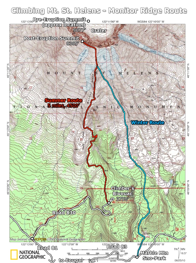
- Route map - shows summer and winter routes up Mt. St. Helens (the road to Climbers Bivouac is closed in winter)
- Green Trails Maps: Mount St. Helens, WA #364
- Green Trails Maps: Mount St. Helens NW, WA #364S
- U.S. Department of Agriculture, Forest Service: Mount St. Helens National Volcanic Monument & Administrative Area
- U.S. Department of Agriculture, Forest Service: Gifford Pinchot National Forest
Trip Reports
- Search Trip Reports for Mount Saint Helens
- St Helens summit 1/29/15
- Mt St Helens summit ridge in snow/ice, 11/30
- Mt St Helen's via Monitor Ridge (7-19-2014)
- Mt St Helens summit - Jul-05-2014
- Mt St Helens Monitor Ridge June 9
- St. Helens 06-08-2014
- Mt St Helens Summit - June 7
Related Discussions / Q&A
- Search Trail Q&A for Mount Saint Helens
Guidebooks that cover this hike
- 100 Hikes in Northwest Oregon & Southwest Washington by William L. Sullivan
- A FalconGuide to Mount St Helens by Fred Barstad
- Best Hikes Near Portland by Fred Barstad
- Washington's South Cascades' Volcanic Landscapes by Marge and Ted Mueller
- Exploring Washington's Wild Areas by Marge & Ted Mueller
More Links
- Climbing Mount St. Helens (USFS)
- Climbing (Mount St. Helens Institute)
- Climbing Mount St. Helens (MountStHelens.com Information Resource Guide)
- Mt. St. Helens Rim Hike (Northwest Hiker)
- Mount Saint Helens (SummitPost)
- Mt St Helens - Monitor Ridge Trail (EveryTrail)
- Ptarmigan Trail #216A (USFS)
Contributors
- Fallsfreak (creator)
- bobcat