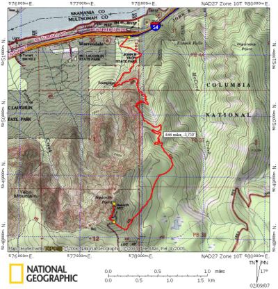
Nesmith Point Hike
From Oregon Hikers Field Guide
- Start point: John B Yeon Trailhead
- End Point: Nesmith Point
- Trail Log : Trail Log
- Hike Type: Out and Back
- Distance: 10.6 miles round trip
- Elevation gain: 3800 feet
- Difficulty: Difficult due to elevation gain
- Seasons: Apr-Oct
- Family Friendly: No
- Backpackable: Yes
- Crowded: No
Contents |
Hike Description
So you think you want to climb mountains, huh? This climb is a good stamina builder, and it's often used by mountain climbers in training. You'll have some great views along the way, and you'll burn a few carbs too.
This hike starts in the John B Yeon State Park parking lot. This place might be the highest-theft lot in the gorge. Leave your valuable things at home! You'll start up the trail, pass an old water tank, switchback, and come to a trail junction, all in the first 50 steps. Take the right trail fork, marked as the Nesmith Point Trail #428.
The first mile of the trail doesn't climb too steeply. You'll pass a former trail junction with the Gorge Trail #400, headed west. This trail was completely wiped out by a 1996 landslide. Some books say it's gone permanently and some say it will be rebuilt, but there's scant evidence of it for the time being.
The hike then continues up the Nesmith Point Trail and here we really mean up! Switchbacks are the norm, and they're pretty steep. However, you'll earn several viewpoints as rewards for your climbing, including views of Mount Adams, Mount Saint Helens, the south face of Beacon Rock, and most of the Washington side of the Columbia River Gorge, as well as good looks at the huge 1996 landslide that started from Nesmith and closed the freeway for days.
After about two miles of heavy climbing, things get a little easier. You'll traverse the top of the ridge, still climbing, until you reach a closed road about five miles from the trailhead. Turn right on the road and hike about 500 feet to the end of the road and the location of an old fire lookout. Trees have grown up here, but you'll still have a good view to the east. For a better view, continue down a small path past the lookout and the old lookout outhouse. A short distance down the slope, there's a great lookout with a view of the entire gorge. Soak in the sights and return the way you came.
Climbers setting out for Nesmith Point in winter and early spring should watch trip reports for snow levels and trail conditions. While the lower part of the Nesmith Point Trail is navigable in moderate snow, it can disappear altogether on the upper reaches, causing climbers to drive their way straight up a ravine or simply kick-step a convenient path or two uphill. As with many higher-elevation hikes in the Gorge in winter, the ridge route to Nesmith Point can be equally difficult to trace, making snowshoes, effort, route-finding skills, and good judgment essential.
History
Nesmith Point is named for James Willis Nesmith, a Canadian born lawyer and politician who moved to Oregon in 1843. He served as a captain in the militia forces during the Rogue River War in 1853 and the Yakima Indian War in 1855. From 1857 to 1859 he was superintendent of Indian affairs for Oregon and Washington Territories and later was elected U.S. Senator from Oregon (1861-1867) after the state achieved statehood.
In March, 1915, the Oregon Historical Society working with the Mazamas and the Oregon Geographic Board, named the peak Mount Nesmith, noting that it was "the highest point immediately adjacent to the Columbia River between Portland and The Dalles." The naming was done "in honor of Oregon's pioneer Indian fighter and Senator Colonel James W. Nesmith, a pioneer of 1843."
Maps
- Maps: Hike Finder
Fees, Regulations, etc.
- None
Trip Reports
- Search Trip Reports for Nesmith
Related Discussions / Q&A
- Search Trail Q&A for Nesmith
Guidebooks that cover this hike
- Day Hike! Columbia Gorge, by Seabury Blair, Jr.
- Afoot and Afield Portland/Vancouver, by Douglas Lorain
- 35 Hiking Trails, Columbia River Gorge, by Don & Roberta Lowe
- Columbia River Gorge, 42 Scenic Hikes, by Don & Roberta Lowe
- Hiking the Columbia River Gorge - 1st and 2nd Editions, by Russ Schneider
- 100 Hikes in Northwest Oregon - 3rd Edition, by William L Sullivan
More Links
Contributors
- Stevefromdodge (creator)
- Jim Sifferle
- CherokeeDriver
- aircooled


