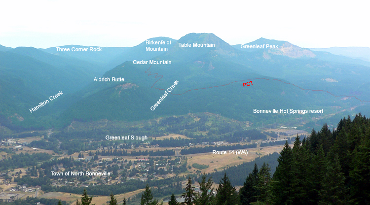
Aldrich Butte
From Oregon Hikers Field Guide
- Hikes to this location:
- Aldrich Butte Hike (TH | <— —> | LOG)
- Hike including this location:
- Aldrich Butte-Cedar Falls Loop Hike (TH | <— —> | LOG)
- Cedar Mountain Loop Hike (TH | <— —> | LOG)
- Weather forecast: NWS/NOAA
- Maps: Oregon Hikers Maps Google Maps
- Latitude, Longitude: 45.65326, -121.97992
- Elevation: 1,141 feet
Description
Aldrich Butte (the "ch" is pronounced) is an oft-seen but lesser traveled butte on the Washington side of the Columbia River Gorge near the town of North Bonneville. It sits in the shadow of nearby Table Mountain and is almost indistinguishable from its surroundings when seen from viewpoints on the Oregon side of the river. Despite its lack of character, it is quite a nice location for those wanting a great view for not a lot of effort. It's a great alternative for families who have done hikes like Angel's Rest and are looking for something different and pretty safe.
While the top of Aldrich Butte does not give you a full 360 degree view, the views are fantastic, especially given the easy hike. It overlooks the Columbia River near the Bonneville Dam. Looking southwest from the summit you see the Nesmith/Yeon ridge on the Oregon side. Following the ridge to the left, you can see Munra Point, Wauna Point and the Eagle Creek Gorge. Looking eastward you see Bonneville Dam, the Bridge of the Gods and the swollen river upstream as far as Wind Mountain and Dog Mountain. The view directly west is obscured, but there are a few viewpoints on the way up that give you a closeup view of Hamilton Mountain. There is a view to the north with Cedar Mountain immediately in front of you and Table Mountain towering just to the right.
When you reach Aldrich Butte, you will see the remains of some old stonework and a pronounced clearing. The history is very interesting here. Before World War II, it was the site of a fire lookout. But during the war the site was commandeered by the military needing an overlook in defending Bonneville Dam. A road was built to the summit in 1942 and several large guns and a small house-quarters were installed. Of what little remains is a large obelisk with a tripod-like threaded nub at the top - looking very much like a gun mount. There is a matching one at the top of Wauna Viewpoint (not surprisingly on the other side of the gorge overlooking the dam). Both are in relatively good condition.
Shortly after the war, the road was used mainly by tourists. Some commercial outfits charged a quarter a head for a trip to the top and back. Today, the road to Aldrich Butte is in pretty rough shape, but given a rugged 4WD vehicle it's doable. There is no way to drive to the public easement without crossing private property - so those doing so are trespassing.
More Links
- NWHikers.com Hike #18
- L&C's Columbia River - A Photographic Journey
- History of nearby North Bonneville
- Historic photo of the building of an old logging road on Aldrich
Contributors
- jeffstatt (creator)


