Cedar Mountain
From Oregon Hikers Field Guide
- Hike including this location:
- Cedar Mountain Loop Hike (TH | <— —> | LOG)
- Weather forecast: NWS/NOAA
- Maps: Oregon Hikers Maps Google Maps
- Latitude, Longitude: 45.6648, -121.9862
- Elevation: 1686 feet
Description
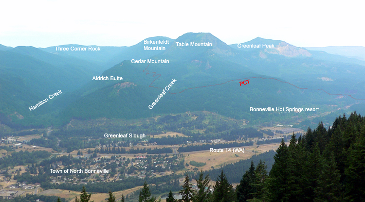
Cedar Mountain is the local name given to a highpoint of a north-south ridge in the Table Mountain region of the Columbia River Gorge. It sits just east of Hamilton Creek in Southwest Washington, but is pretty tough to spot amid the other distinctive landmarks in the immediate area - particularly Aldrich Butte, crouching in front of it like a younger brother at a photo session.
There is no established trail up to the summit - and the summit is somewhat in question as well! The most common route to the top is to take the Cedar Falls Trail (there is a sign at the start of the trail calling it the "Aldrich Falls Trail" - which was likely nailed up by a local hiker) to a very light footpath that follows a ridge to a viewpoint on the west side. This footpath is a bushwhack at best! The view overlooking the Hamilton Creek valley is a surprisingly good one! There are 200-300 feet seasonal waterfalls that cascade down the side of nearby Hamilton Mountain into this valley. If you come on a clear day in the winter months you will be treated to some of the rarest waterfall sightings in the Columbia River Gorge.
There is also a nice viewpoint on the eastern ridge of the mountain. It overlooks the entire Greenleaf Creek watershed and Table Mountain. Again, this is a pretty unique perspective! For someone who values the out-of-the-way places in the Gorge, this is a fairly easy place to get to for some great solitude.
The whole area encompassing Aldrich Butte, Cedar Mountain and Hamilton Creek was once a hotbed of forestry during the turn of the last century. Railroad beds and debris are scattered all around these forests - some can be dated back to the late 1800s.
More Links
Contributors
- jeffstatt (creator)


