Eagle Creek Hike
From Oregon Hikers Field Guide
- Start point: Harvey Road Trailhead
- End Point: Eagle Creek Ford
- Hike Type: Out and Back
- Distance: 15.4 miles round-trip to the Eagle Creek Ford
- Distance: 6.8 miles round-trip to the Eagle Creek Riverside Camp
- Elevation gain: 2360 feet
- High Point: 2,405 feet
- Difficulty: Moderate
- Seasons: Mid-spring into winter
- Family Friendly: Yes (for a shorter in and out)
- Backpackable: Yes
- Crowded: No
Contents |
Description
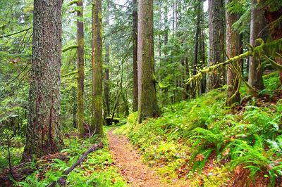
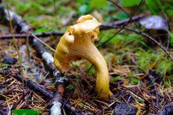
The “other” Eagle Creek does not have the splashy waterfalls and sheer gorge walls of the iconic hike of the same name in the Columbia Gorge although there are a couple of falls in the area that can be reached by an intense bushwhack. Rather, this trail rambles along the course of a main tributary of the Clackamas River in mossy Cascade foothills old growth with big trees that survived a series of burns in the second decade of the 20th century. In fact, the creek valley was much more open at that time, and the trail was originally constructed to allow cattle access for grazing, with permits dating back to 1901. Nowadays, forest flowers carpet the duff in spring and summer, and in fall you can take advantage of the fruiting of edible fungi. Several campsites along the trail beckon for a quiet night out, and the farther you hike in, the less likely you are to see traces of other humans. This is a great hike in the off-season when there is no snow below 2,500 feet, the main difficulty being finding the trailhead on an access road frequently used by logging trucks. Since this is an in and out hike, you can turn back whenever you want; the old Eagle Creek Riverside Camp is a good destination for a shorter outing.
Take the middle road down from the trailhead area. (If the road is not blocked, you can drive 0.4 miles down to a landing and park.) The road as far as the landing has been graded and water-barred. At the landing area, pick up the old road bed leading down to the left. The track is overhung with regenerating Douglas-fir, western hemlock, red alder, and big-leaf maple (The area was logged in the 1970s.) You'll enter national forest lands and then see a wilderness entry sign. The road bed continues to descend under alders and passes the junction with the Douglas Trail. Through a break in the trees, you'll get a glimpse of clearcuts on the hillsides above Eagle Creek. After crossing a brook, you will notice that the trees are increasing in size and you can hear Eagle Creek rushing below. The track bends left and soon you leave the road bed and begin to hike along a gently undulating duff trail which parallels Eagle Creek although the latter is still out of sight.
Now there are larger trees to admire: western hemlocks, western red-cedar, and especially some large fire-scarred Douglas-firs that survived several burns over 100 years ago. The forest carpet is classic west Cascades foothills: moss, sword fern, deer fern, Oregon grape, and salmonberry, with some beautiful glades of shamrock-leaved oxalis. After passing through a salmonberry clearing, get a glimpse of the creek below. The trail gently ascends a little, and you'll pass some impressive Douglas-firs. A side trail leads down to the creek and then a short spur leads up to the left to a leveled spot that once may have supported a fireman’s shed at the time of the burns. After crossing a stream, walk along a short, rotting boardwalk, and cross another tumbling creek. After crossing another creek, notice another spur to a campsite on the right. Make a traverse in a green bottomland. A trail leads right down to the creek and the Eagle Creek Riverside Camp. This quiet spot, about 3 ½ miles from the trailhead, is a good turnaround point for those making a shorter excursion.
Continuing on the main trail, cross a large stream (which may have to be forded early in the season) and then traverse about 100 feet above Eagle Creek. As you hike along a sheer slope, you'll step across more streams and pass through salmonberry thickets in mossy woods. The trail reaches a bottomland at creek level among drooping hemlocks, cedars, and salmonberry thickets. From here, the path rises and crosses a large creek before traversing a mossy bench. Then you'll make a level traverse about 50 feet above Eagle Creek. After crossing a little gully, hike through an oxalis carpet in a lush bottomland. The trail rises and you make another traverse high above the creek, getting a view upstream. After crossing another tributary, find yourself right above Eagle Creek and drop into a salmonberry bottomland with groves of cedar and Douglas-fir. From now on, you may be shoving your way through the thick salmonberry. A faint trail leads to a campsite closer to the creek. After rising to cross a tumbling brook, the trail drops into an open salmonberry flat shaded by a few gnarly old alders. Then the path veers right to a ford of Eagle Creek. This is also the meeting point with the Eagle Creek Cutoff Trail #504, as denoted by a barely legible old sign. Across the creek, the cutoff trail heads steeply up the slope of Githens Mountain to a junction with the Old Baldy Trail.
Maps
- Maps: Hike Finder
- Green Trails Maps: Cherryville, OR #460
- Adventure Maps: Mt. Hood Area
- U.S. Department of Agriculture, Forest Service: Salmon-Huckleberry Wilderness, Bull of the Woods Wilderness, Opal Creek Wilderness, Opal Creek Scenic Recreation Area
- U.S. Department of Agriculture, Forest Service: Zigzag Ranger District
- U.S. Department of Agriculture, Forest Service: Mt. Hood National Forest North
- U.S. Department of Agriculture, Forest Service: Mt. Hood National Forest
- National Geographic Trails Illustrated Map: Mount Hood
Trip Reports
- Search Trip Reports for Eagle Creek Hike
- Eagle Creek Trail (Estacada) #501 - May 13, 2022
- Eagle Creek (Salmon Huckleberry Edition)
- The "other" Eagle Creek 6/30
- Eagle Creek Trail #501 3/13
- The Other Eagle Creek, 10-Jan-2014
- Eagle Creek (Salmon-Huckleberry Wilderness)
- The Other Eagle Creek
- Eagle Creek (the other one!) 11/12
- Eagle Creek to McIntyre Ridge via Pablo's Way 06/27/10
- The "Other" Eagle Creek (#501) June 12-13, 2010
- Eagle Creek (Salmon-Huckleberry Wilderness) 05/10/09
- Chak Chak Falls & Tipsu Falls along the "other" Eagle Creek
- Eagle Creek to Wildcat Mtn loop Aug 5, 2007
Related Discussions / Q&A
- Search Trail Q&A for Eagle Creek Hike
- Eagle Creek in Salmon Huckleberry: evidence of ***hole motorbiker
- Lower Eagle Creek Weyerhauser moonscape
- The other Eagle Creek Trail
- TKO Project - The "Other" Eagle Creek (Oct. 11, 2008)
Guidebooks that cover this hike
- Off the Beaten Trail by Matt Reeder
- Afoot and Afield: Portland/Vancouver by Douglas Lorain
- Oregon's Wilderness Areas by George Wuerthner
- 100 Oregon Hiking Trails by Don & Roberta Lowe
- A Walking Guide to Oregon's Ancient Forests by Wendell Wood
More Links
- Eagle Creek Trail #501 (USFS)
- Eagle Creek Trailhead (USFS)
- “Discover the other Eagle Creek Trail in the Salmon-Huckleberry Wilderness” (Examiner.com)
- Eagle Creek with Don and Murphy - February 2012 (Green Cascadia)
Page Contributors
- bobcat (creator)


