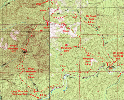
Elk Creek Hike
From Oregon Hikers Field Guide
- Start point: Elk Creek Trailhead
- End point: West Fork Elk Creek Road Junction
- Trail log: Log
- Hike type: In and out
- Distance: 7.2 miles round trip
- Elevation gain: 2020 feet
- High Point: 2885 feet
- Difficulty: Moderate
- Seasons: All year, except during winter snowfall
- Family Friendly: Yes, for older kids
- Backpackable: No
- Crowded: No
Contents |
Hike Description
The Elk Creek Trail is an easy route that follows an old logging road (West Fork Elk Creek Road) that gradually but relentlessly ascends the west and north slopes of Elk Mountain. It's a good hike for winter months when the snow levels are above 2,000 feet. For about half the distance, you will be above Elk Creek and then the West Fork Elk Creek before the track begins switchbacking up in earnest. The lush secondary forest here also supports a rich array of wildflowers in the spring.
If you’re parking here in the winter, hike past the gate down the campground road. The alder-lined Devils Fork of the Wilson River flows down to your left. Soon, you’ll reach the walk-in campground staging area, with the campsites on a shady bench at the confluence of the Devils Fork and Elk Creek. There are restrooms here also. Continue across the road bridge over Elk Creek to the summer trailhead. Keep right here, and walk past a boulder and cable across the decommissioned Elk Creek Road. This track also serves as a continuation of the Wilson River Trail.
Hiking up the road bed, pass a spur trail that leads right to Elk Creek. You can make a short loop back to the road from here to view a waterfall that splashes down into the creek. Continuing on the road, pass another a spur that leads to a rocky narrows on the creek. Walk around a slide that has eaten away part of the road bed. Douglas-firs form a canopy, while baby alders crowd the trail before you reach a sign indicating this is the junction where the Wilson River Trail peels off to descend and cross Elk Creek. A new (2017) single handrail bridge has been installed to span both the West Fork and Elk Creek for part of the year (May to October). The bridge is removed from mid-fall to mid-spring.
Now you're hiking above the West Fork Elk Creek, which gushes down a rocky course to the right. Alders have fallen like matchsticks across the creek. A path detours into the forest where the road bed was completely washed away in November 2006 floods. The road track then makes two big looping switchbacks where violets blooms on the verge. Then you'll cross the first of several gully slides. The road emerges on an open slope where paintbrush and penstemon bloom in spring as you traverse the headwaters of the West Fork. You'll make two shorter switchbacks in a constricting alley of young alders, and then continue up in Douglas-fir woods to pass a mossy spring and arrive at the West Fork Elk Creek Road Junction.
To the left, it's another 0.8 miles to the three-way Elk Mountain-Kings Mountain Trail Junction, from which you can reach the summit of Elk Mountain (see the Elk Mountain Loop Hike). The main road bed continues to the right, leading on to heavily logged private timberland and, eventually, Russell Point.
Maps
- Maps: Hike Finder
- Kings Mountain, Elk Mountain & Elk Creek Trails (Oregon Department of Forestry)
- Oregon Department of Forestry: Tillamook State Forest Map & Guide
Fees, Regulations, etc.
- Trailhead access road gated in winter
- Share trail with mountain bikes
- Check for snow conditions before hiking here in winter
Trip Reports
- Search Trip Reports for Elk Creek
- Elk Creek Trail - hiking, trail maintenance, and a surprise!
- Elk Creek Trail/ Tillamook State Forest 9/9/12
- Elk Creek Trail in the snow 03-17-12
Related Discussions / Q&A
- Search Trail Q&A for Elk Creek
Guidebooks that cover this hike
- Best Hikes Near Portland by Fred Barstad
- Afoot & Afield: Portland/Vancouver by Douglas Lorain
- Take a Hike: Portland by Barbara I. Bond
- 50 Hikes in the Tillamook and Clatsop State Forests by the Sierra Club, Oregon Chapter
- 50 Hikes in the Tillamook State Forest by the Tillamook State Forest Committee, Columbia Group Sierra Club
More Links
Contributors
- User:retiredjerry (creator)


