Gold Butte Lookout Hike
From Oregon Hikers Field Guide
- Start point: Gold Butte Trailhead
- End point: Gold Butte Lookout
- Trail Log: Trail Log
- Hike type: Out and back
- Distance: 3.2 miles round-trip
- Elevation gain: 800 feet
- High point: 4,618 feet
- Difficulty: Easy
- Seasons: Summer - late fall
- Family Friendly: Yes
- Backpackable: No
- Crowded: No
Contents |
Hike Description
A gated road, very rough in its upper stretches, leads to a historic and remote lookout with views up and down the Oregon Cascades. The lookout itself can be rented for the night at Recreation.gov, so you may find occupants upon your arrival at the top.
You'll begin the hike on the gated gravel access road. Rhododendrons bloom here in early summer. The elevation gain is mild for a half mile as you walk through a forest of hemlocks and rhododendron. You will get a few views to the west as the road gets steeper and finally ends at the official trailhead at 1.3 miles. The trees will diminish as you make the final steep switchback ascent to the summit for the last quarter mile.
If guests are staying at the lookout, please give them their privacy. The lookout itself was constructed in 1934 by the CCC (Civilian Conservation Corps). During World War II, the lookout served as part of a warning system against enemy aircraft.
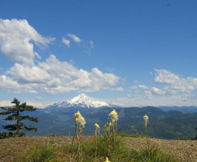
The jumbled rocky ridgetop that juts northward invites scrambling and exploring, with some good spots for having lunch on top of the world. Views extend north past Battle Ax to Mount Hood. Looking south, you'll make out Mount Jefferson, Three Fingered Jack, and the Three Sisters.
Maps
- Maps: Hike Finder
- Green Trails Maps: Battle Ax, OR #524
- U.S. Department of Agriculture, Forest Service: Salmon-Huckleberry Wilderness, Bull of the Woods Wilderness, Opal Creek Wilderness, Opal Creek Scenic Recreation Area
- Geo-Graphics: Bull of the Woods and Opal Creek Wilderness Map
- U.S. Department of Agriculture, Forest Service: Willamette National Forest: Detroit Ranger District
- U.S. Department of Agriculture, Forest Service: Willamette National Forest
- Pacific Northwest Recreation Map Series: Willamette Cascades
Regulations, Restrictions, Facilities, etc.
- Lookout available for rental; outhouse near the lookout
Trip Reports
- Search Trip Reports for Gold Butte
Related Discussions / Q&A
- Search Trail Q&A for Gold Butte
Guidebooks
- Fire Lookouts of Oregon by Cheryl Hill
More Links
- Gold Butte Lookout (Outdoor Project)
- Hike to the Gold Butte Fire Lookout (The Outbound)
- A Unique Experience at Gold Butte Fire Lookout Tower (Aperture Adventure)
- Fall at Gold Butte (Every Lookout in Oregon)
- Gold Butte Lookout (Travel Oregon)
- Gold Butte Fire Lookout (All Trails)
- Gold Butte Lookout - Willamette National Forest - Oregon (Odd Inns and Uncommodations)
- Gold Butte and Hawk Mountain Wrapped (Every Lookout in Oregon)
- Gold Butte Lookout (USFS)
- Gold Butte Lookout (Recreation.gov)
Contributors
- CFM (creator)


