

Table Rock Hike
From Oregon Hikers Field Guide


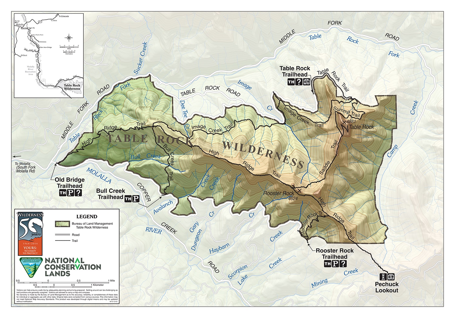
- Start point: Table Rock Trailhead

- End point: Table Rock
- Hike type: In and out
- Distance: 7.2 miles
- Elevation gain: 1570 feet
- High point: 4,881 feet
- Difficulty: Moderate
- Seasons: Summer into Fall
- Family Friendly: Yes, for older children
- Backpackable: Yes
- Crowded: Sometimes
Contents |
Description
Table Rock is a 4,881-foot remnant of the Old Cascades jutting above the Camp Creek and Table Rock Fork of the Molalla River drainages and buttressed by sheer cliffs of lichen-splashed columnar basalt. It is the heart of the 6,028-acre Table Rock Wilderness, administered by the Bureau of Land Management. Much of the route described here was ravaged by fire in the 1880s, but a lush mature coniferous forest now cloaks the slopes. The forest, talus slopes, and dry meadows on top of Table Rock support a diverse flora and views extend from Mount Rainier to the Three Sisters. This hike is 2.6 miles longer than it used to be thanks to a large 1996 landslide on the access road. The BLM found the area to be too unstable for longterm repairs and moved the trailhead back 1.3 miles.
From the parking area, pass the outhouse and head up the old alder-rimmed road bed. There are several trickling creek crossings. At 0.3 miles the old roadbed abruptly ends at the 1996 landslide, which is pretty well overgrown after 20+ years of tree growth. Just before the landslide a trail heads into the woods of silver fir, western hemlock, and Douglas-fir. This detour trail traverses the slope high above the old slide and descends back down to the road. Continue up the road, passing under imposing rock pinnacles. Sitka alder cloaks the bottom of a scree slope. There are views to the northeast. At 1.3 miles reach the old trailhead and turn right, hiking up the trail through cool woods past a thicket of rhododendrons, which bloom in July, before coming to the Table Rock-Summit-Image Creek Trail Junction, with the Image Creek Trail coming down from the right.
You are now on the Summit Trail. The path here is rooty and blooming with rhododendrons in early summer. The trail levels and then rises and makes a traverse along a steep slope with a creek to the right. Head up a slope below a rock spire. Rise around the nose of a ridge and head up below a rock face brightly emblazoned with rock penstemon before passing through a vine maple thicket. There’s a scramble trail to the right going to the rock pinnacle. The trail makes a traverse through Douglas-fir, silver fir, noble fir and western hemlock forest. A spur right leads to a viewpoint. Curve around a talus slope below a cliff and drop through a thimbleberry/Sitka alder thicket with the basalt columns of Table Rock's cliffs looming above. Listen for pikas squeaking their alarm calls. Here you can catch a view of the top of Mount Hood. Also admire the veritable rock garden at the foot of these cliffs. The path heads into woods and then crosses a scree slope with thimbleberries. The trail rises gradually among rhododendrons, silver and noble firs. At a saddle, reach the unsigned Summit-Saddle Trail Junction, where there is a campsite but no water source. (Note: if you wish to add on a side trip to Rooster Rock, the trail heads uphill through the trees just before reaching the saddle. It is not on the opposite side of the saddle.)
To reach the top of Table Rock, go left here and traverse up among mountain hemlock, western white pine, silver fir, Douglas-fir and noble fir. Bear-grass and huckleberries rim the trail. There’s a switchback and Alaska yellow-cedar appears in the mix. The trail reaches the summit ridge with a great view of Rooster Rock, Mount Jefferson, clearcuts, Olallie Butte, and Mount Hood. On a clear day, you will see down the Oregon Cascades to the Three Sisters and north to the Washington peaks, including Mt. St. Helens, Mt. Adams, and Mt. Rainier. Back in the wooded area of the summit, you can find a survey marker and a campsite. In summer, there are many blooms among the mats of pinemat manzanita and common juniper.
Fees, Regulations, etc.
- none
Maps
Trip Reports
- Search Trip Reports for Table Rock Hike
- Table Rock Wilderness Wildflowers
- Table rock near Molalla
- Table Rock Wilderness 20-Apr-2014
- Table Rock, May 27, 2012
- Table Rock 7-19-2011
- Table Rock/Rooster Rock/Pechuck Lookout 7/4-5/11
- Table Rock Wilderness 7.02.11
- Table Rock Wilderness hike 6-8-09
Related Discussions / Q&A
- Search Trail Q&A for Table Rock Hike
Guidebooks that cover this hike
- Day Hikes in the Pacific Northwest by Don J. Scarmuzzi
- Oregon Hiking by Matt Wastradowski
- Pacific Northwest Hiking by Craig Hill & Matt Wastradowski
- 52 Hikes for 52 Weeks by Franziska Weinheimer (Hike Oregon)
- 105 Virtual Hikes of the Mt. Hood National Forest by Northwest Hiker
- 101 Hikes in the Majestic Mount Jefferson Region by Matt Reeder
- 100 Hikes: Northwest Oregon by William L. Sullivan
- Hiking Oregon by Donna Lynn Ikenberry
- Oregon's Best Wildflower Hikes: Northwest Region by George Wuerthner
- Portland Hikes by Art Bernstein and Andrew Jackman
- Oregon's Wilderness Areas by George Wuerthner
- Hiking Oregon's Geology by Ellen Morris Bishop
- Oregon's Columbia River Gorge: Camping & Hiking by Tom Stienstra & Sean Patrick Hill
- Oregon Hiking by Sean Patrick Hill
- Pacific Northwest Hiking by Scott Leonard & Megan McMorris
More Links
- BLM'sTable Rock Wilderness (BLM - on YouTube)
- Table Rock (Summit Post)
- Four Hikes in Search of Sasquatch (Trailkeepers of Oregon)
- Table Rock Wilderness (Wilderness.net)
- Table Rock (Mountain Plants of the Western Cascades)
- Table Rock (Northwest Wildflowers)
- DRAFT Table Rock Wilderness Plan Update (BLM)
Page Contributors
- bobcat (creator)