

West Fork Illinois River Loop Hike
From Oregon Hikers Field Guide


,_BLM_Main_Road,_Illinois_River_Forks.jpg)


- Start point: West Fork Trailhead
- Ending point: West Fork Illinois River
- Hike type: Loop
- Distance: 3.8 miles
- Elevation gain: 680 feet
- High point: 1,695 feet
- Difficulty: Easy
- Seasons: All year
- Family Friendly: Yes
- Backpackable: No
- Crowded: No
Contents |
Hike Description
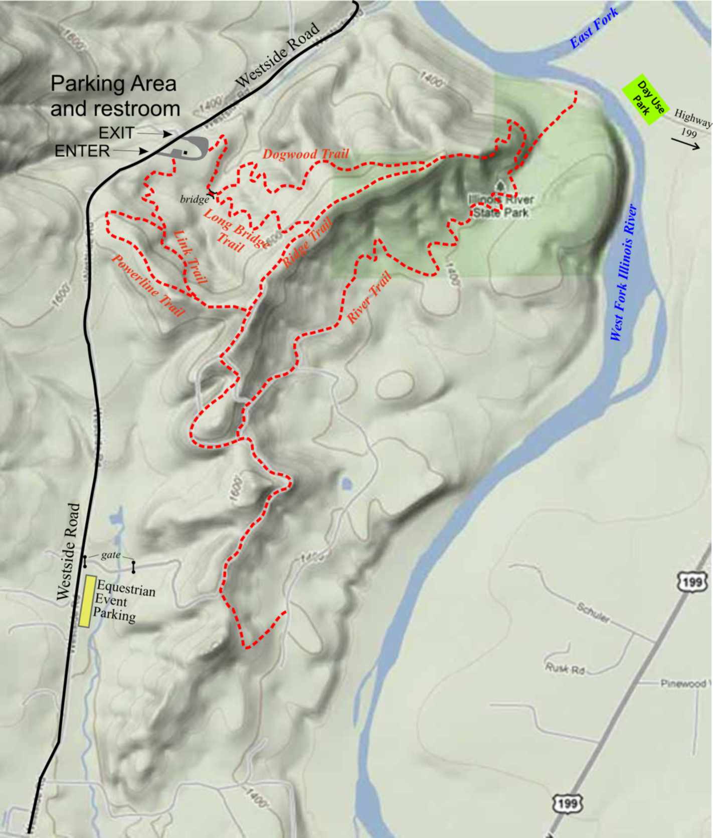
The East and West Forks of the Illinois River meet just south of Cave Junction, with the main recreational area, mostly BLM land administered by Oregon State Parks, laid out between the two forks. However, the lengthier, more secluded trail system loops around a forested ridge above the West Fork. You are likely to be the only person on these trails which, although they offer very limited access to river and no views to speak of, allow you to wander through a typical Siskiyou mixed forest of pine, Douglas-fir, myrtle, madrone, and oak. Pay attention to the junctions, where maps are posted although some are now faded and unreadable. You’ll be hiking both on state park land and abandoned logging roads on BLM property. A proposal in the works calls for extending the trail system almost 2,000 feet up to the summit of neighboring Woodcock Mountain. Even more distant plans call for connecting the east side and west side trails with a bridge over the West Fork.
Walk down the road from the trailhead to reach the horse trailer parking area. The loop begins opposite horse trailer space #1. Enter a mixed woodland of Douglas-fir, knobcone pine, sugar pine, California black oak, and Pacific madrone. Switchback above a gully, and cross an oak-lined creek on a footbridge. There’s a junction across the creek which, like the other junctions in the area, has a map of the trail system. Go left here on the Dogwood Trail, and head down along the creek. Drop into a gully, and then ascend a slope. Pass into another gully, and then wind up a slope with views to Woodcock Mountain on your left. Make a traverse to hike over the nose of the ridge. Hike below the crest on a sword fern slope, passing below a big Douglas-fir. The path drops and then rises past more large Douglas-firs and gnarly old madrones. Reach a crest, and take the River Trail leading left.
Continue down along the ridge, and make six switchbacks. Note some evergreen myrtle trees in the understory. Reach a junction above a gully. Here, make a sharp left to descend gradually above a trickling brook. This trail is not always maintained, so you may have to clamber over downed trees. Elk trails cross the path at regular intervals. Pass through an oak wood, and enter a shady myrtle forest along the West Fork Illinois River. Head towards the river through the trees, but be careful – there’s an old barbed wire fence strung above the river bank. You’ll reach the brushy verge of a secondary channel of the West Fork about 200 yards above its confluence with the East Fork.
Head back to the junction, and keep left on the River Trail. Pass above a small meadow, and cross a gully with a few manzanita shrubs. Walk across an oak draw before hiking up a mossy slope and descending once again, this time into a deeper gully. Pass the BLM boundary marker, and reach a spur road. This track soon becomes grassy as it rises through a previously logged forest. Get a view through the trees to Bolan Mountain. At a junction with another road track, keep right and ascend gradually up a ridge crest through the manzanitas and under a tall pine. This crest once had views to the Siskiyou peaks along the California-Oregon border, but trees have since grown up. Come to a bench chained to a tree where another spur road leads left.
Take this road, which soon ends, and drop down the hill on the Link Trail to a saddle, where you join another road track. Traverse a lush sword fern slope, and arrive at the junction with the Powerline Trail. Go left to pass the State Parks boundary and drop down a ridge with the outline of Woodcock Mountain, the crest of which was the western fireline for the huge 2002 Biscuit Fire, looming ahead. Reach the powerline corridor: from here you can see the trailhead below. Bear right to recross the open corridor, and come to the second junction with the Link Trail. Keep left to head back across the powerline corridor, and switchback twice down to a footbridge across a gully. Recross the corridor one more time to descend to the trailhead.
Fees, Regulations, etc.
- Restrooms at trailhead
- Share trails with horses
Maps
- Maps: Hike Finder
- Westside Trail Map (Highway 199)
- Eastside Trails and Westside Trails, Illinois River Forks State Park (Highway 199)
Trip Reports
- Search Trip Reports for West Fork Illinois River Loop Hike
Related Discussions / Q&A
- Search Trail Q&A for West Fork Illinois River Loop Hike
Guidebooks that cover this destination
- none
More Links
- Illinois River Forks State Park (Oregon State Parks)
- Illinois River Forks State Park Trails (Highway 199)
- Illinois River Forks (Oregon Parks and Recreation Commission)
Page Contributors
- bobcat (creator)